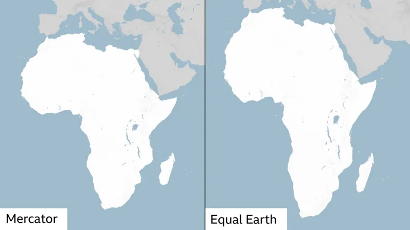
The United Nations General Assembly has backed a resolution calling for wider use of a world map that more accurately represents Africa’s enormous size.
The “Correct the Map” resolution, sponsored by Togo and supported by African Union members, passed with 164 votes in favour. France and the UK were among those supporting the resolution. The United States was the only country to vote against it, while six nations abstained.
The resolution challenges the continued dominance of the Mercator projection, a map created by Flemish cartographer Gerardus Mercator in 1569.
The Mercator map has long been criticised for distorting the apparent size of landmasses. Countries and regions closer to the poles appear much larger than they actually are. This makes Greenland appear roughly comparable in size to Africa on many versions of the map. In reality, Africa covers about 30.4 million square kilometres, compared with roughly 2.2 million square kilometres for Greenland. Africa is therefore about 14 times larger than Greenland.
Critics argue that such distortions can shape how people perceive different regions. They say Africa’s scale, development needs and economic potential can be understated when its size is visually reduced.
However, the distortion is not simply a flaw in the Mercator map. Representing a spherical Earth on a flat surface inevitably creates distortions. Mercator’s projection was designed primarily for navigation. It helped European explorers plot routes by preserving certain directional relationships.
The General Assembly’s resolution is non-binding. However, it is expected to encourage institutions around the world to reconsider the maps they use.
READ ALSO: https://alo360.net/nepal-tunnel-rescue-flood-survivors/

